Pinjarup, Kaniyang Country
Day 8 and 9. Dwellingup to Harvey Quindanning Road 10th 11th Dec 2016 – 64.5kms
This section of the Bibbulmun Track was to be memorable for all the wrong reasons. It wasn’t a good decision to walk that weekend as Saturday was predicted to reach 36C, however I always carried plenty of water far in excess of what was recommended and I counted on the shade from the forest giving some relief.
As I left Dwellingup it was already warm. There were still flowers around this late in the season with all of Bull Banksia, Prickly Mirbelia and Twining Fringe Lily common.

There were a few climbs coming out of the pine plantations 7kms from Dwellingup but I made good time, and it wasn’t long before I had reached Swamp Oak Campsite. It was far too hot for a brew so instead I polished off 1.5 litres of water and some fruit.
It was as I left Swamp Oak Campsite that things took a turn for the worse.
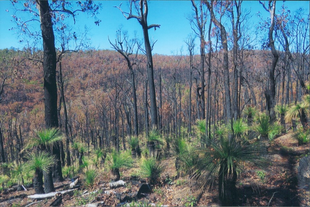
The previous January a devastating fire had swept through the area, ultimately resulting in the destruction of the town of Yarloop and the death of two people. The aftermath of these fires was all around me as I climbed out of Swamp Oak Brook. The ground was scorched and the forest canopy had been obliterated, leaving no protection between myself and the burning overhead sun.
I disturbed a Boobook Owl as I climbed surprised that anything would now be living in such a desolate place. By the time I had reached the crest of the hill overlooking Yarrigil Brook and the Murray Valley I was feeling faint.
The descent was very steep and hard on the knees. After I had crossed Yarrigil Brook I had an extremely hard ascent up the side of the valley. Taking a break was out of the question in the beating sun and besides there were so many flies ready to settle there was no relief in stopping. I quickly became very dizzy but all I could do was keep drinking water and press on.
Once past the steep climb I joined a railway formation but a new problem confronted me, the landscape was so burned that it was hard to keep on the track, the fact that the Waugal markers were also black and charred made the job no easier. I did lose the track a few times but I kept calm and retraced my steps.
Eventually I came out of the burnt forest and descended to the tranquil Murray River, disturbing a Brush Wallaby and coming head to head with a Southern Heath Monitor.
The Murray River was an oasis of calm after the scorched hell I had walked through earlier that afternoon, although even here was evidence of an earlier fire.

Despite being very tired I did have a quick 15 minutes with the spotlight around the hut but found nothing. Lying in the hut that night waiting for sleep to overtake me I thought over the events of the day and decided in the future to read the track conditions before I walked…lesson learnt.
I woke in the morning and ate breakfast under the magnificent River Banksia between the river and the campsite.
Today was to be another part of the track where large sections had been burnt, which was disappointing, but as I followed the Murray River the undergrowth obviously provided habitat for wildlife because I disturbed both Brush Wallabies and Emus.
There were parts of the track I passed where vegetation was not affected by fire including creeks with stands of River Banksia. The path itself was covered with dead leaves and in the dappled sunlight of the early morning something caught my eye. It was a Carpet Python!

See also my post South West Snakes – Western Australia – Carpets and Tigers
This magnificent specimen must have been about 1.5 metres long! It provided me with a long break as I observed and photographed it then reluctantly I pushed on.
Despite all the hardship of the previous day this one thing had made the weekends walking worthwhile. Only my second Carpet Python in the wild! Woohoo!
The track alternated between hugging the riverbank and climbing higher up the side of the valley but unfortunately the burnt vegetation didn’t make the river valley a pretty site at the time I walked through.
After the track left the river, a notice had been placed on the track advising walkers of a diversion in place to cross the River Murray further South because the February 2015 fire had destroyed the Long Gully Railway Bridge.
This was not an option for me as I didn’t have enough water for an additional 11km nor the desire to walk that extra distance on this a 30C day so I climbed the long and gentle hill up to Dookanelly Campsite my rest stop for the morning.
The walk from Dookanelly to Harvey-Quindanning Road was not a particularly nice section of the track. There was a number of steep hills in quick succession and once again a lot of the vegetation had been burnt to the point where losing the track was a very real worry. This is because post fire new Jarrah shoots often come directly out of the trunk therefore obscuring track markers.
In the event crossing the Murray River was no problem, as water levels were low, anyway about 200m downstream there was a fallen log that got me across without so much as getting my toe wet. I felt validated by my decision not to follow the diversion.
Day 10 and 11. Harvey Quindanning Road to Coalfields Hwy 31st Dec 2016 1st Jan 2017 – 57.4kms
I find New Years Eve is a night that I would rather not celebrate in the conventional style. Instead I prefer to go to bed early and start the new year with a clear head, so it made perfect sense to wake up to 2017 on the track.
A continuation of the burnt forest from my last walk was the feature of the track from the Harvey-Quindanning Road to Possum Springs Campsite and so this early part of the walk does not rate much of a mention.
After Possum Springs the contrast in vegetation could not have been greater. I passed though the most beautiful section of the track to date.
The vegetation was varied as I passed first through the Plonkhole, with its wetland species, then through a large stand of beautiful virgin forest, and finally onto the Harris River Flats where there were huge numbers of Swamp Banksia and Paperbarks.

It was obvious this was healthy forest because of the huge numbers of Brush Wallabies (the greatest anywhere on the track.)
Yourdamung Campsite was in such a beautiful location nestled at the foot of a large stand of Virgin Jarrah.

Once dinner was finished and darkness had fallen I set out with a spotlight to look for wildlife in this pristine area. Regrettably the only wildlife I found was a Brush Wallaby, nonetheless happy with my location I said goodbye to 2016 and fell asleep.
The following morning the bush was just as lush as it had been the previous afternoon, consisting of massive Jarrah (including a massive King Jarrah,) and low lying areas of Swamp Banksia. Brush Wallabies were again in good numbers and Summer Starflower was dotted over the forest floor.
Approaching Harris Dam Campsite there was a magnificent stand of Bull Banksia. After the obligatory morning cuppa at the campsite I continued to the Coalfields Highway passing the lovely Harris Dam Picnic Area and further small stands of Swamp Banksia.
As I approached the Collie area, sadly the forest once again became fire affected so I was glad to reach the Coalfields Highway the end of the walk.
When I returned to my car, parked next to the remains of the Long Gully Bridge on Harvey-Quindanning Rd in the designated parking area, I found the front two panels of the car badly damaged. A dishonest person and a bad driver to boot had put a 4WD bull bar into the side of the car and slunk off without leaving a note. A real punch in the guts. Humans never fail to disappoint me.
Hopefully in this case it is true that bad luck comes in three’s and I hoped that the triumvirate of getting lost at Mt Wells, the burnt forest episode at the Murray Valley and now this was the last of it.
Day 12, 13 and 14. Coalfields Hwy to Balingup 1st 2nd 3rd April 2017 – 88.8kms
I had managed to score a Monday off work, so with the hot WA summer on the wane, it was once again time to walk the Bibblulmun.
I had a new pair of hike boots, which I hoped once worn in, would reduce the blisters I was getting with the previous boots.
I dropped the car at the Visitor Centre in Balingup, trusty Lorenz then gave me a lift to the Coalfields Highway, where I had finished the previous walk on New Years day.
The first part of the walk to the Collie Spur Trail passed without event other than to say it was beautiful sunny morning for walking.
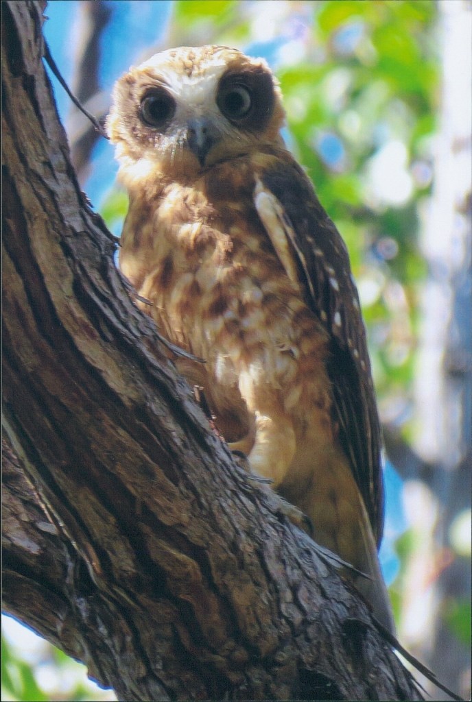
On the next part of the track I disturbed a Boobook Owl, except unlike the previous one South of Dwellingup, this one flew into a perch from where I was able to photograph it.
I soon reached the Collie River and the remains of the old railway bridge collapsed into the river. The next major feature on the track was the attractive Mungalup Reservoir which the track skirts around.

I was making good progress, and before long I had passed the Wellington Spur Trail, arriving at Yabberup Campsite earlier than expected. A fellow walker had already set up for the night and we passed the time chatting while I brewed up.
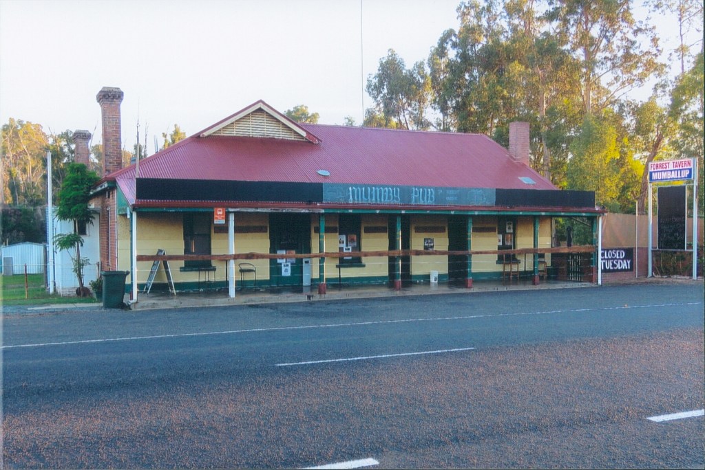
It was here I made the decision to push on for the Mumballup Tavern as there was still feasibly time before dark. I had my tent with me so it wasn’t necessary for me to be at a hut for the night, also the pull of a non-dehydrated meal and a cold pint was too much to resist for this foot weary walker.
As I walked on from Yabberup I came across an attractive new species of plant flowering, one I had not seen before. I later identified it as a Round Fruit Banksia. It was quite common on this section of the walk.
I passed Glen Mervyn Dam, and was glad not to be camping there for the night when the sounds of MC Hammer’s “You can’t touch this,” echoed across the water from some noisy campers.
The sun had set by the time I reached the Mumby Pub and I promptly ordered a hot meal and my first of many pints! The pub is not usually allowed campers but as there was an Adam Brand concert the following night a special license had been granted for people to camp this weekend.
I set up my tent and joined Emmy, Kaye and Glennis at their caravan for drinks. They were Adam Brand fans down from Bunbury for the following days concert. After a great few hours of beer and good conversation I retired to my tent for a deep sleep.
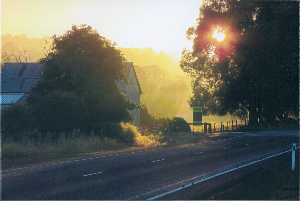
The following day I woke with the birds before any other campers had stirred. I found the Preston Valley bathed in mist and the first rays of the sun breaking through.
I shouldered my back and set off down the disused railway line adjacent to the road. The Bibbulmun then climbs the side of the valley up Hearle Road, through pleasant farmland, to the Greater Preston National Park.
It was cool pleasant walking in the forest at this early hour and other than disturbing a Brush Wallaby, approaching Noggerup Campsite, the walk was peaceful. Breakfast at the campsite was fruit and a dehydrated porridge meal washed down with tea.
Heading South on the old railway formation there were many Red-capped and Twenty Eight Parrots feeding next to the track, which flew to the tree tops as I tramped past.
I noticed the vegetation slowly starting to change as I was now reaching the cooler damper South West corner of the State.
There were thick Rushes and Sedges in the creeks, Soap Bush was becoming a more permanent feature and I passed my first Peppermint Tree of the walk. Walking the old rail formations through the forest I noticed wild Plum Bush for the first time on the walk.
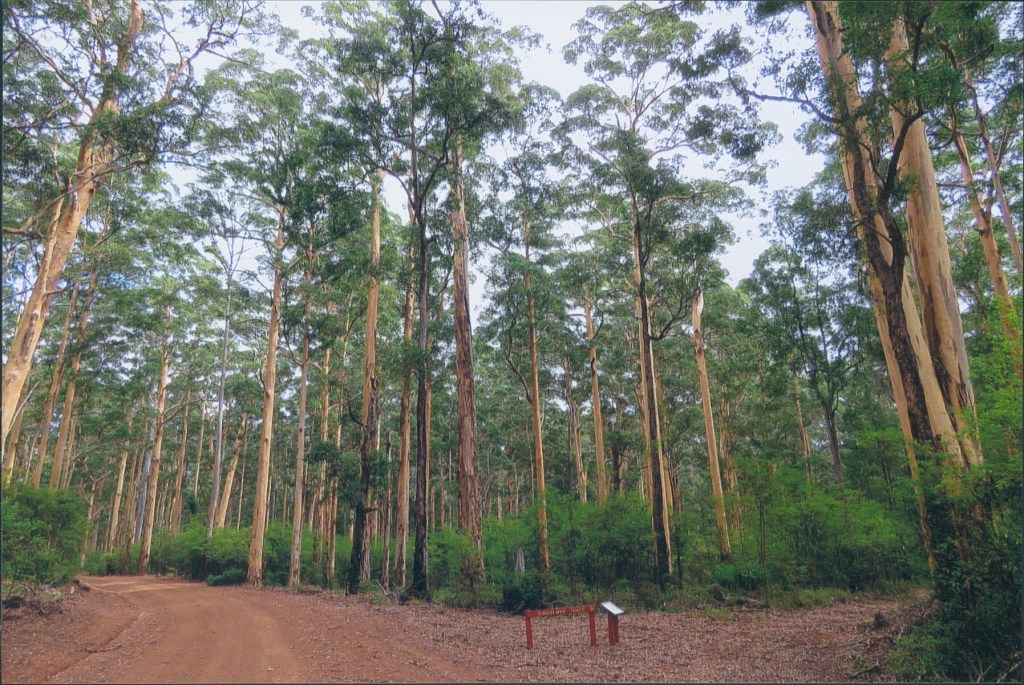
I was enchanted to pass through more Virgin Jarrah Forest, always a highlight of any day on the track.

I reached Grimwade Campsite mid-afternoon, too early to stop for the night, so once again I decided to press on with a hope of arriving back in Perth earlier the following day.
Also influencing my decision was the notice on the foundation website of the intention of a large group to camp at Grimwade for the night.
In the event this group turned out to be the Scotch College group I had met the previous year at Mt Wells (I recognised the teacher.) Just as I had done last time I ran into them I promptly took a wrong turn. They were definitely starting to become a bad omen for me!
This wrong turn only involved a kilometre as opposed to the 15.4km wrong turn I took last time at Mt Wells, and was a result of tiredness and taking my eye off the ball.
Light was failing so I set up camp next to the track, just past Kirup-Grimwade Rd, ate my dehydrated meal and crashed for the night.
Monday morning the first part of the walk unfortunately passed through more burnt forest. After I crossed a creek the track ascended to a spot with wonderful views over farmland. In the field I disturbed a mob of Emus, who when they saw me, promptly bolted for the safety of the adjacent forest.
The track alternates between forest and farmland approached Balingup, before it descends into Balingup Brook Valley, and crosses the brook on a wooden bridge.
Balingup Brook Valley is a hot spot for birds and as I walked into town I saw Red-eared Firetails, Brush Bronzewings, Western Rosellas, Fairy Wrens and Scarlet Robins.
Arriving at Balingup I had a coffee and breakfast firmly in mind, but before that, there was the important task of photographs with the Balingup scarecrows, to end what had been a thoroughly enjoyable three days on the track.

Day 15 and 16. Balingup to Donnelly River 14th 15th April 2017 – 58.1kms
Easter weekend the weather presented the opportunity of four days walking, but due to commitments I only walked for two days.
I left the car in the same spot as the previous walk at the Balingup Visitor Centre, logged in at the walker logbook, then set off South.
I wasn’t sure exactly how I was going to tackle the walk, but with a late 11.30 start it was looking increasingly likely that I would be walking in the dark, if wanted to stay at Gregory Brook Campsite.
The start of the walk through the Golden Valley Tree Park provided a variety of Autumn colours as the deciduous trees of the park beginning to shed their leaves. Exiting Golden Valley there was a long and gradual climb up Old Padbury Road back into the Jarrah forest.
I had two wildlife encounters in this lovely patch of Jarrah Forest. First there was a rather bold Western Yellow Robin, not too concerned at all with my presence, unlike most of the generally shy small forest birds.

The second encounter was an impasse with a rather sleepy Bobtail Lizard in the middle of the path. This lizard was not moving, so despite being the bigger of the two in the stand-off it was me that had to walk around!

The forest understory was denser than anything encountered further North and it was nice to experience the vegetation change.
It was a little confusing to find that I was suddenly walking the Greenbushes Loop Trail and I was unsure if I had taken a wrong turn at some point, although in the end I had to put faith in the fact that any fork in the track is always very clearly marked. Then as I passed a dam with stands of River Banksia I was relieved to come to the fork and know that I was definitely on the right path!
Once out of the Jarrah Forest I descended Spring Gully Road through a lovely patch of farmland with disused sheds and livestock before a hard ascent up the other side of the valley.
The last part of the walk to Blackwood Campsite was a disappointment passing through the pine plantation it was also incredibly hard to reconcile where I was with the guide book for this last part of the section.
Blackwood Campsite sits in a magnificent spot on the top of a hill with spectacular views over the Blackwood River Valley but the view was ruined by the bare hillsides of harvested pine plantations in every direction.

I was ready for my first cup of tea of the day at the campsite but I discovered that this idiot had forgotten an essential part of the jetboil stove when packing for the trip. The cup of tea would have to wait and so too would my hot evening meal.
I pressed on with the intention of reaching Gregory Brook Campsite for the night realising this would involve walking an hour in the dark. This was no problem because it would give me a chance to spotlight the forest at night.
Leaving Blackwood Campsite I descended Cardiac Hill then followed the course of the Blackwood River before a steep ascent up to Millstream Dam. This was a really beautiful area at this time of the day and I regretted not having time to linger.
Leaving the dam, I walked through the forest as dusk fell, eventually turning into a black moonless night. The track at night, as I had found previously, was very easy to follow because of the reflective capabilities of the Waugal markers.
I was happy for once to know that I was passing through burnt forest because it wouldn’t have made for pleasant daytime walking. The hour I walked with the spotlight I didn’t see or hear any wildlife.
Approaching Gregory Brook I hoped for the place to myself but in the event there were five walkers already at the hut, the busiest hut I had overnighted on the track.
I decided to set up my tent before turning attention to dinner. Dinner options were limited without hot water, so I added cold water to my muesli and yogurt dehydrated breakfast which turned out to be bloody delicious after the hard day on the track. I joined a lovely couple at the picnic table while I ate my dinner then exhausted I retired to my tent and almost instantly fell asleep.
The following day I rose with first light and ate a breakfast of fruit. Today was the day that I would be entering the Karri Forest for the first time so I was saddened that the day was so gloomy. I had been warned by my fellow walkers at the campsite that the first part of the mornings walk would be through bushfire affected forest indeed there was a large tree still smouldering from a fire the previous year!
Once I reached Guy Rd I found numerous fruiting Wild Plum Bush (Podocarpus drouynianus.) I had always wanted to taste this bush tucker so I sampled one to find the fruit sweet almost plum like with a slightly sour aftertaste.
I hoped to have my first break of the day at Karri Gully, but being Easter weekend the rest stop was full of campers, so I pressed on to have a break in the solitude of the forest.
After crossing the Brockman Highway, I entered more burnt Jarrah Forest. It was clear to see that the Native Plum had benefited from the fire because nearly every bush I passed was laden with fruit. Next, I descended in to more typical Karri Forest with Water Bush surrounding the track.
The track here was clearly an old rail formation level and straight. The thick understory of the Karri Forest provided few views but this understory gives the walker an opportunity to let the mind wander because it is impossible to lose the track.

The guide book mentioned the awe of walking in the Karri Forest for the first time and while this was indeed the case, for me the highlight of this part of the walk were the incredible stands of River Banksia.
I knew that I was about to enter a grove of River Banksia because the Banksia was flowering and the call of the Western Wattlebirds echoed through the forest as they defended their territories around this very important food source.

The history of the timber industry was clear to see in this part of the forest as the track passed through numerous railway cuttings and passed over old rail bridges made of Karri.
The last part of the walk before reaching the Donnelly River Settlement followed Snake Rd through the Karri understorey and here birds were a constant companion with Grey Fantail, Golden Whistler, Red-winged Fairy Wren and Red-eared Firetails birds I was able to identify.
The old timber town of Donnelly River was a welcome sight. I made straight for the general store where I ordered ginger beer one of the best pies I have ever tasted and a bar of chocolate.
Afterwards waiting for my lift I explored the settlement. There were many tame Emus and Kangaroos around and good birdlife also, this was somewhere that would be great to spend a weekend in the cooler months!

Donnelly River is the generally accepted halfway point, so it is here that my account on the Northern half of the Bibbulmun Track finishes. It had been a wonderful experience and if I had to pick three highlights they would be (in no order)
Monadnocks Conservation Park
The Virgin Jarrah Forest around Yourdamung Campsite.
The magnificent stands of River Banksia approaching Donnelly River Settlement.
I must acknowledge my wonderful partner Lorenz, who over the previous year has dropped me off and picked me up for every leg I have walked, and without whom this adventure would not be possible. I am hoping he will join me to experience some of my soon to come Southern half of the Bibbulmun Track adventure! Continued in Bibbulmun Track Part 3 – Donnelly River – Pemberton – Northcliffe – Walpole – Still Rivers and Giant Karri Country (309.3kms)
#QuollingAround

One thought on “Bibbulmun Track Part 2 – Dwellingup – Collie – Balingup – Donnelly River – Pythons and Scarecrows (274.3kms)”