Arrernte Country
This Three part blog is an account of thirteen days walking the 223 kilometre Larapinta Trail. It is split into a day by day account of the trek, and on each day I have added a short account of one aspect of the logistics of walking the trail for those planning to walk. I hope you enjoy reading about the trail as much as I enjoyed walking it…..
Alice Springs
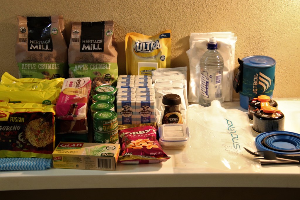
I arrived in Alice Springs 24 hours before I was due to start walking the Larapinta Trail. This time was used was to purchase food for the walk. LTTS (Larapinta Trail Trek Support) had dropped three containers at the accommodation prior to my arrival.
https://www.treksupport.com.au/
The night before walking, the food and surplus gear was divided into four. The first part would go into the pack for the initial three days on the trail, the remaining three parts would be split into the three containers, to be dropped off by the company at pre-arranged storage sheds on the trail. These would be accessed at Standley Chasm, Ellery Creek South and Ormiston Gorge.
LTTS Container Drop Boxes.
I also visited Olive Pink Botanical Garden to view some of the wildlife of Alice Springs both before and after the trek. See the link below for a brief account documenting wildlife seen:- The Wildlife of Alice Springs – Australia’s Desert Heart
Day 1 – Alice Creek Telegraph Station to Simpson Gap – 24.7kms
Sunday 5th September 2021
I set out later than planned on the Larapinta Trail, waiting in Alice Springs for tourist information to open at 9am to buy maps for the trail, to replace the maps purchased (and lost) the day before!
The eastern trailhead of the Larapinta is 4kms north of Alice Springs at the Telegraph Station. I arrived at 10am after hitching a lift from Alice Springs. The day was the coolest of the entire trek at 19C, and the morning was overcast with cloud lingering from the rain event two days prior. Perfect conditions for the first day of walking. A few obligatory photos at the trailhead and I was on my way.
The landscape on this first day is described as undulating, at first this was a reasonable description as the trail meandered over and around the hills northwest of Alice Springs, passing first under the Stuart Highway that links the cities of Adelaide and Darwin, then over the railway track that links these far-flung cities.
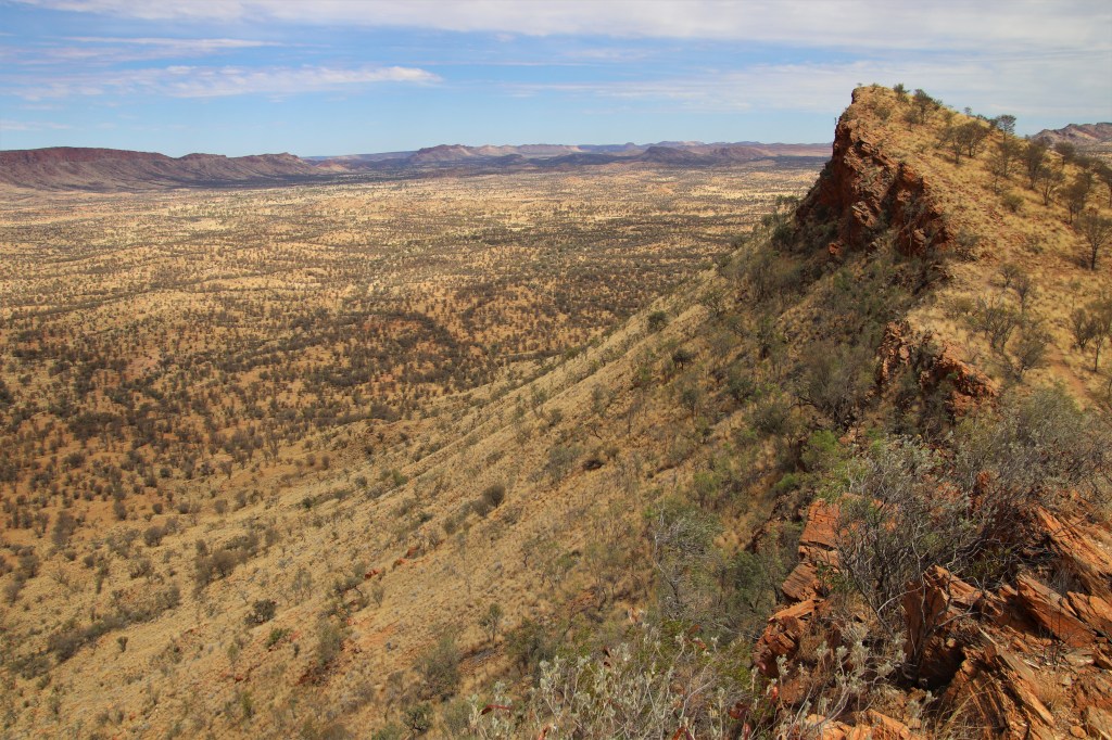
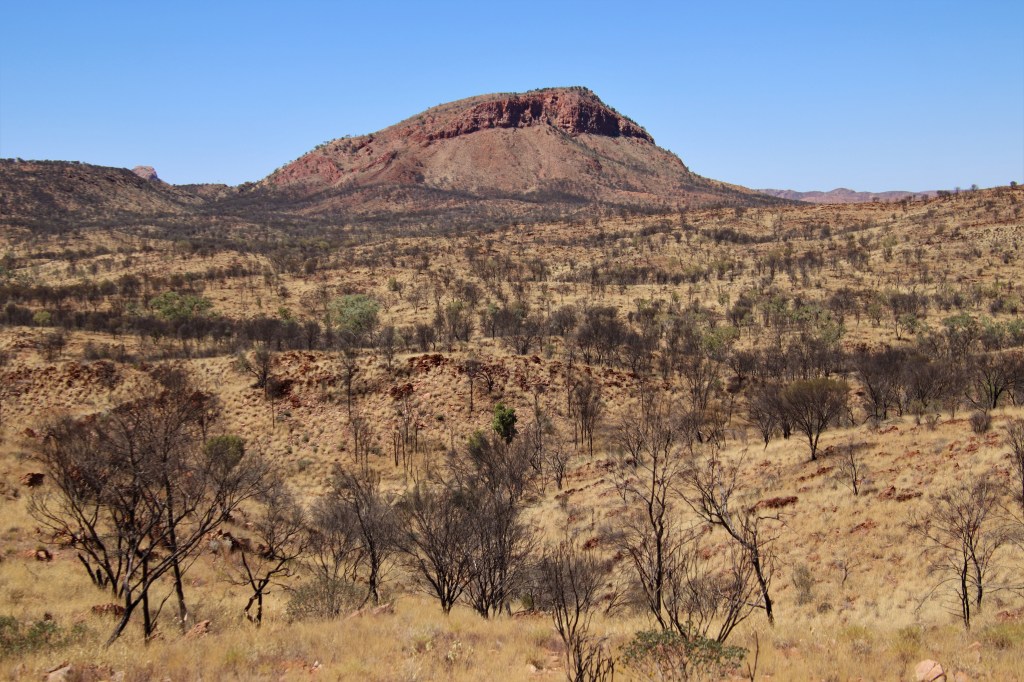
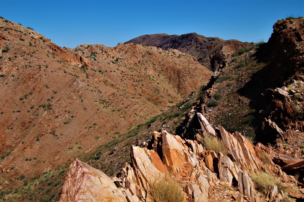
As the morning progressed the climbs became larger and larger, until just before lunch I found myself high up on Euro Ridge with amazing views South to the Heavitree Range and back to Alice Springs. Undulating my bloody arse, this was hard-going!
Euro Ridge looking South to the Heavitree Range.
I was elated to arrive at Wallaby Gap, lunch stop for the day, after a steep descent off Euro Ridge. Wallaby Gap is the first shelter heading west on the Larapinta Trail.
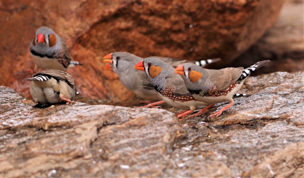
This was only the halfway point of the first day and I was already knackered, so it was good to take a rest eating lunch. A recent visitor to the campsite had not closed the water tank tap securely and a flock of Zebra Finches were taking advantage of the small pool that had formed in the rocks under the tank. There were also a couple of bold Willie Wagtails around camp, one of whom perched on my boot, waiting for lunch scraps to fall.
Zebra Finches coming in for a drink at Wallaby Gap.
The afternoon walking started gently as the trail travelled along the foot of the range, but in a repeat of the mornings walk it finished with another decent climb, this time into acacia woodland on the steep slope of Rungutirba Ridge. Views were great however, as the setting sun illuminated Hat Hill Saddle ahead, indicating the end of the walking for the day was approaching.
Late afternoon in an indication of what was to come, there were rodents were scampering across the trail. The previous wet season in the Western Macs had been a good one, and there had been a resulting explosion in the rodent population.
Hat Hill Saddle.

I rolled into Simpson’s Gap after 4pm truly cooked. It had been a hard day’s walk with a couple of sizable climbs, although I was only too aware bigger climbs were to come.
There are two camping areas for Larapinta walkers at Simpson Gap. The first is 200m past the main carpark, the second, where the shelter is located is another 200m past the first. I was too tired to walk the last 200m to the shelter and so set up in the dirt at the 200m campsite.
While I was setting up the tent, a fellow walker passed heading to the shelter, and so we had a chat. This was Matty B from the NT, who had set out on the trail on the same day. We walked the majority of the trail within a similar time frame, and it was always a pleasure to run into Matty B in the days ahead.
I visited Simpson’s Gap at dusk to search for Black-footed Rock Wallabies in the obvious scree slope on the eastern side of the gap. There was an icy wind blowing through the gap and any sensible Rock Wallabies would have holed up in their caves, I didn’t see any. I did however, almost step on a rather confiding Budgie foraging for seed along the path returning to the tent.
As I ate dinner back at the campsite, I revisited the day. It had undoubtedly been a struggle. One easy way to reduce the weight carried was to halve the water. Carrying 4.5 litres of water was not necessary on cool days when tank water could be accessed at 12km intervals.
I was in the tent before darkness and asleep within minutes, although during the night I was vaguely aware of the rasping screeches of a Barn Owl somewhere far across the Alice Valley below.
What is the best direction to walk the Larapinta?
I walked the Larapinta Trail east to west ie Alice Springs to Mount Sonder. I chose to walk this way because I found it appealing to walk towards Mount Sonder, a clearly visible end point for the latter half of the trail. Also having the sun behind in the morning when I did the majority of walking was pragmatic.
It is also worth considering the Larapinta Trail was designed to be walked this way, meaning a relatively easy first two days of walking, and the largest elevation, the climb up mighty Mount Sonder, on the last day.
Day 2 – Simpson Gap to Jay Creek – 26.2kms
The following morning dipped to a cold 3C, the coldest morning of the walk. I was up at first light and briefly visited Simpson’s Gap before breakfast for another crack at the Rock Wallabies (no success.) I packed up and started walking, more to keep warm than anything else! There were good views back to Simpson’s Gap as the trail headed south, before once again turning west.
Simpson’s Gap.
During the second day the terrain was flatter, making for easier walking. The 9.2km from Simpson Gap to Bond Gap was covered in a couple of hours, and the shady gorge at Bond Gap made an excellent mid-morning rest stop.
The Larapinta Trail circumvents the most spectacular landmark of the day Arenge Bluff passing to the south. It was a shame not to see these west-facing cliffs of the bluff light up a fiery orange, as they are reputed to do late afternoon.
Arenge Bluff.
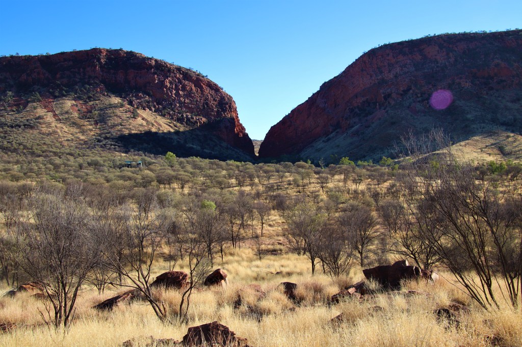
I found Mulga Camp a rather uninspiring campsite (water, no shelter,) that served as lunchbreak for the day. I didn’t linger. The Larapinta Trail then cuts through the Chewings Range at Spring Gap, where the calls of Budgies constantly rung out from the River Red Gums. The trail gets a little hazy at Spring Gap and I know I was not the only walker that briefly lost the trail.
The final seven kilometres of the day were along a low ridgeline covered in Mulga Woodland, on the north side of the Chewings Range. It wasn’t particularly inspiring walking but there were a few birds around, including Splendid Fairy Wrens and the odd Little Button-quail to frighten the walker as it exploded from the ground into flight next to the track at the last minute!
It was 4pm when I finally arrived at Jay Creek Campsite. After establishing that of the four walkers present at Jay Creek that night, only myself and Matty B would be using the shelter, I set up the tent on the platform within the hut, out of the cold wind. The remaining two hikers were camping in the tent sites surrounding the hut.
One of the walkers, a rather affable chap from Adelaide, was heading in the opposite direction. Over dinner, valuable information was gained about the upcoming days. Walkers heading in the opposite direction are the best source of information I was to find time and again. Once again I was in my sleeping bag before darkness had truly fallen.
What Guidebooks are available for the Larapinta Trail?
There is a book entitled “Larapinta Trail” by John and Monica Chapman, unfortunately this book was out of stock everywhere. The old editions had been snapped up by the larger than usual number of Australians walking the Larapinta due to the closure of international borders. A new edition is being currently being written, but at the time of writing was not yet available.
An alternative information source was “The Larapinta Trail Pack,” consisting of a series of six booklets enclosed in a plastic sleeve, each detailing two sections of the trail. It is available to buy online and also from Alice Springs Visitor Centre.
I would have preferred to carry the book than a series of booklets. In the event, I found The Larapinta Trail Pack marvellous and really informative, not only on the physical trail but also on the wildlife and geology of the Western MacDonnell Ranges.
Day 3 – Jay Creek to Standley Chasm – 13.6kms
Another cold morning, another early start. Section three however, had me excited for two very good reasons. The first being it was half the kilometres of the first two days. The second was the promise of a Standley Chasm burger at the end of the section! I couldn’t get my boots on quick enough!
I left the hut shortly after first light for the walk through gorge immediately south of the campsite that cut back through the Chewings Range. This first gorge walk was fairly easy, alternating between the sand and rocks of the creek bed to Fish Hole.
There is a short sharp climb on the western edge of the pool before some easy walking to Tangentyere Junction, where walkers have a choice of route. The easy route is along the valley floor to Millers Flat. The harder route ascents Tangentyere Ridge.
In common with most people, the initial few days on the trail had been a struggle, but by day three I was finally starting to get my walkers legs. I knew that the challenges on days four and five were going to be some of the hardest on the track so I took up the challenge and walked the high route in preparation.
Almost immediately I had my decision validated when a I disturbed a Diamond Dove feeding on the ground up onto a branch, where it propped nicely for a photo.
Diamond Dove.

Time for once was an ally ascending the numerous switchbacks to climb the 300 metres up the mountain, with regular breaks to take in the awe-inspiring views. There were exceptional panoramas from the top, south to the Heavitree Range and further ahead along the Chewings Range. As I sat and took a well earned rest out of the wind, I correctly speculated that the highest peak ahead in the range was Brinkley Bluff, where all being well, I would camp the following night.
First though, the steep descent down a small gully. It was harder than the ascent! I lost the trail a few times but I figured as long as I kept descending “she’d be right.”
Pools had formed in the rocks, surrounded by lush vegetation. These pools were a magnet for a variety of birds including Diamond Doves and Zebra Finches, and it was here I saw my first Painted Finches on the trail.
My knees were delighted to reach Millers Flat, where the walking was temporarily easier, before the scramble up beautiful Cycad Creek. There was abundant vegetation within the creek and birds were once again plentiful drinking from residual pools along the creek floor. In addition to the birds seen earlier in the day there were large numbers of charismatic Budgerigars.
The trail ascends a sheer 5m rock face within Cycad Creek. Although this would seem a daunting prospect, it was actually quite easy. Trail markers clearly depict the only real route, and I didn’t even need to remove the pack.
It was late morning with warm temperatures as I reached the top of Cycad Creek and arrived at Gastrolobium Saddle to an amazing view! I was breathless after the climb but this view really did take my breath away. In that moment I suddenly understood why people raved about the Larapinta.
What a View! Approaching Standley Chasm.
The northern Approach to Standley Chasm was clearly in sight as I descended Angkale Creek, but if I thought the last few kilometres of the day would be a breeze, I was mistaken.
The trail doesn’t cut through Standley Chasm, instead there are a number of steep climbs and descents on stone steps on the western side of the chasm. I was fairly exhausted after what had been a hard morning and I’m glad nobody was within earshot as I huffed and puffed a range of expletives as I went up and down. Just when you though the climbing was over there was always another climb. It was exasperating.
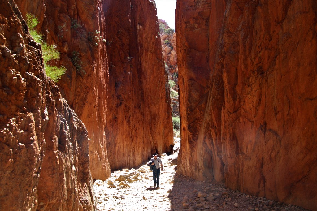
Finally I reached the chasm, where I had been advised to leave my pack at the bottom of the stone steps to make the short diversion to the Chasm. Once there I sat down utterly exhausted amongst the throng of camera-wielding tourists. I must have sat there in a stupor for thirty minutes before I gathered the strength to photograph this Larapinta icon. It was midday and sun poured in from directly above lighting up the orange walls of the chasm
Standley Chasm lit up under the midday sun.
On the short walk to the cafe I retrieved my pack from the bottom of the stone steps, and then finally ordered the burger I had been thinking about all morning. The delectable Chilli Burger was washed down with a Bundaberg Ginger Beer, and damn was it good!
Standley Chasm Chilli Burger.

Standley Chasm is owned and operated by local community members of the Angkerle Aboriginal Corporation, and I was happy to pay the $20 camping fee to camp on site. The tent site was just a dusty strip of grass next to the carpark, but the amenities included a toilet block, washing machine and shower, and of course the proximity to the cafe the following morning.
https://www.discovercentralaustralia.com/standley-chasm-angkerle-atwatye
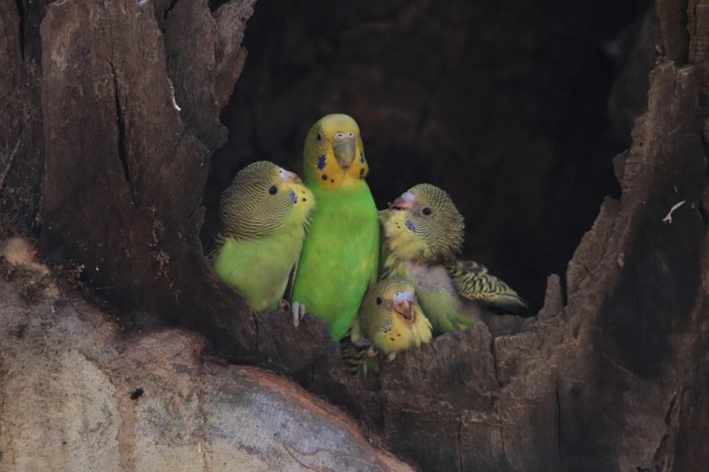
Once I had the tent set up, I explored amongst the River Red Gums where huge numbers of Budgerigars were nesting in the hollows of these stately giants. I had no idea this mass wildlife event was taking place when I booked to walk the Larapinta, but it was incredible.
Every hollow contained Budgie chicks, often a head or two would be peering out of a hole, eagerly anticipating the return of a parent laden with grass seed ready for regurgitation
Budgies at nest hole, Standley Chasm.

One large nest hole contained four chicks, and it was here that I spent the most time. While the parents were away silence reigned supreme but on the return of an adult bird the circus would begin. The four little bundles of feathers would leap into action as they pestered and begged the parent for food.
Budgies at nest hole, Standley Chasm.
When is the best time to walk the Larapinta Trail?
The peak walking season is Winter (June to August,) attractive to some for the cooler daytime temps. I personally avoid trails in peak season, while fellow walkers are a massive part of a trail, too many spoil the experience. Peak season also means crowded huts.
The Shoulder season (Spring and Autumn,) was a more appealing option. At this time, days are mostly warm, but nights generally cool. There are still walkers around, but often it was just myself or one other person at a hut. It is always nice to have the option of setting up the tent on a sleeping platform within a shelter.
September made perfect sense for my walk because there of the increased chance of reptiles at this time of year (not for everyone I’m sure!) September can have some hot days however, and towards the latter part of the walk I endured a few scorchers. The Larapinta Trail can be fatal in Summer, and walking at this time is not recommended.
Day 4 – Standley Chasm to Brinkley Bluff – 9.9 kms
The following morning was the most leisurely start of any on the trail. An excellent coffee and breakfast at the cafe was followed by further Budgie viewing, before striking the tent and finally setting off after 9.30am.
It was already warm as the trail followed a dusty, rocky creekline for two kilometres out from Standley Chasm, before ascending up a steep-sided valley and onto a ridge. I was grateful for the cooling breeze as I once again enjoyed phenomonal views.
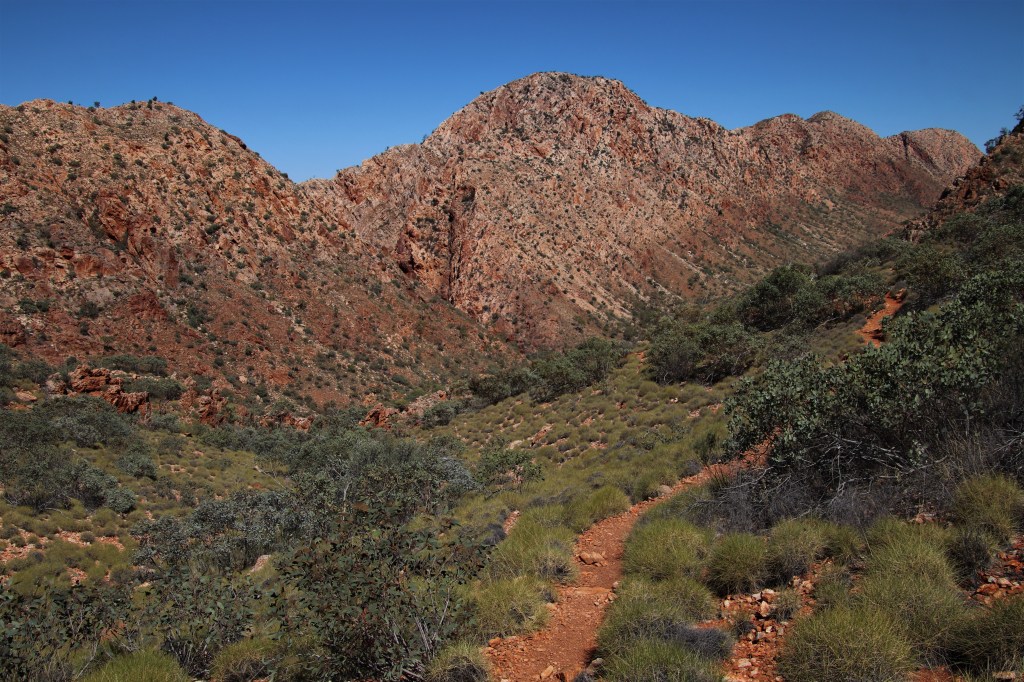
The view from Reveal Saddle ahead to Brinkley Bluff.
After a few false summits I arrived at Brinkley Bluff Cairn by 1pm. This was the shortest walking day of the entire trip at 10 kilometres. Camping on the top of the bluff would hopefully afford excellent sunset and sunrise views.
There were a number of tent sites cleared by previous walkers and I chose a site on the north side of the bluff out of the prevailing southeasterly wind. There were views from the tent west along the Chewings Range all the way to Mt Giles in the distance.
Room with a view. Brinkley Bluff.

The afternoon was warm up on the bluff despite the light breeze, and it was spent reading in the tent out of the sun, until dinnertime.
As the sun hung low in the western sky, I planted myself against the cairn and with sprawling views in every direction and ate a well earned dinner. A paupers dinner with the views of a king! I couldn’t take my eyes from the astounding vistas.
Views back along the Chewings Range to Standley Chasm.

The Heavitree Range from Brinkley Bluff.

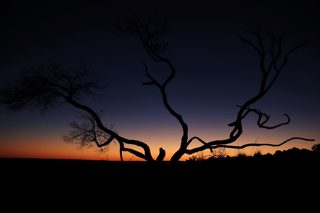
I made the short walk to the western end of the bluff for sunset. Sitting there as dusk cloaked the desert, I had time to process the last four days. The Larapinta Trail had so far been everything I had hoped it would be, and more, and there were still nine days ahead. I was profoundly at peace with the world as the reds and oranges of the sky morphed into blues, purples and ultimately the black of the desert night sky.
Continued in part 2:- The Larapinta Trail – Part 2 – Brinkley Bluff to Counts Point.
Dusk on Brinkley Bluff.
Phone Reception on the Larapinta Trail?
The NT government has installed Telstra hotspots at some highlights on the Larapinta Trail, one can only imagine for the posting of pictures on social media to advertise tourism for the government. These highlights included Simpsons’s Gap, Standley Chasm, Brinkley Bluff, Counts Point, Mt Giles Lookout and Mount Sonder.
There was however, no Telstra reception at Ormiston Gorge (although Optus customers were able to obtain coverage here.) The shelters on the Larapinta Trail contain solar reliant charging facilities.
I carried a phone while walking the Larapinta in case of emergency only. Disconnection from the digital world is one of the joys of walking through the wilderness. I must admit however, that I did find phone reception incredibly useful for monitoring the weather forecasts, especially as conditions deteriorated towards the latter part of the walk.
#QuollingAround

2 thoughts on “The Larapinta Trail – Part 1 – Alice Springs to Brinkley Bluff.”