
Arrernte Country
This three part blog is an account of thirteen days walking the 223 kilometre Larapinta Trail. It is split into a day by day account of the trek, and on each day I have added a short account of one aspect of the logistics of walking the trail for those planning to walk. I hope you enjoy reading about the trail as much as I enjoyed walking it…..
Continued from Part 2 :- The Larapinta Trail – Part 2 – Brinkley Bluff to Counts Point.
Day 8 (contd) – Serpentine Gorge to Serpentine Chalet Dam – 13kms
I would have stayed longer at Counts Point Lookout soaking up the staggering views, but I wanted to seek shelter from the afternoon sun at Serpentine Chalet Dam Hut.
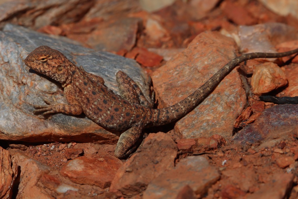
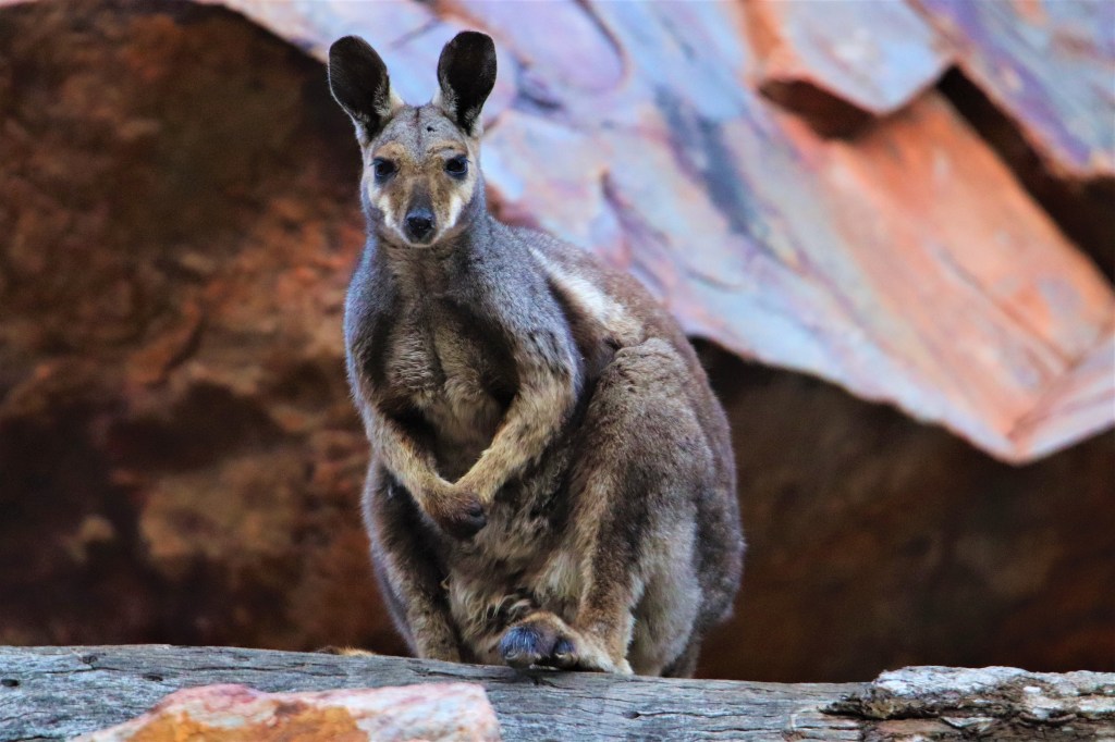
Frequently encountered reptiles of the high rocky country are Ring-tailed Dragons. Descending the steep steps from Counts Point to the valley floor, one of these intricately-patterned dragons was stretched out across a warm rock next to the trail.
Ring-tailed Dragon.
The final approach into Serpentine Chalet Dam was once again relatively easy going along undulating foothills. Reaching the hut I took a nap, one of only two times I managed to do so on the trail, despite a large number of walkers lunching at the hut during this time.
Leon was a slightly mad guy who had reached the end of the trail at Mount Sonder a few days previously, then had promptly turned around to walk it in the opposite direction! The only water during the upcoming section nine of the trail is at Waterfall Gorge. I was able to ascertain from Leon that there was indeed water in the gorge ahead.
Anton and Matilda I had met during the previous afternoon at Serpentine Gorge. Their modus operandi was a late start, then a daytime rest at the hut during the hottest part of the day, before walking into the evening, and sometimes even into the night to camp out on the track. Something I was to adopt later that week. The food they carried was certainly unique, and included pork floss, packets of squid and an assortment of food packets covered in Japanese writing!
In the event it was only myself and Matty B that spent the night at the hut, the others moving on to various points out on the track. Late afternoon I made the short walk up to Serpentine Chalet Dam. This now disused dam was a rather forlorn place, being built to provide water for the now defunct Serpentine Chalet.
Rodents at the Shelters
The rodent population on the Larapinta Trail varies according to the availabilty of grass seed, which in turn is reliant on rainfall. The previous Summer had been a wet one in the MacDonnell Ranges evidenced by the large number of mice at trail shelters.
It is wise to hang food from the shelter rafters to avoid sharing it with rodents. Some, but not all, shelters on the trail contain meshed drawers under the sleeping platform to store food.
Often I would hear mice when I slept in the shelters, but Serpentine Chalet Dam Hut was the shelter at which I personally found mice most prolific. Despite removing all food from my backpack I was woken numerous times by scratching noises eminating from my pack. I think there must have been residual grains of muesli.
I ignored the scratching as long as possible, but it was clear unless action was taken it was going to go on all night. Annoyed at having to leave my warm sleeping bag I leapt up and exclaimed “Party’s Over Mate” before lifting the backpack to the edge of the shelter and tipping the little rascal out into the night. Sleep at last!
Day 9 – Serpentine Chalet Dam to Ormiston Gorge – 28.9kms
The 29km section nine of the Larapinta from Serpentine Chalet Dam to Ormiston Gorge is the longest without tank water. There is however, ephemeral water at Waterfall Gorge halfway along this section. Numerous walkers heading east had confirmed the presence of water, but the condition of the water described varied greatly. I hoped the 4.5 litres carried would be sufficient for the day, but it was a relief to know there was back-up if required.
I was thankful the 26C forecast for this long day of walking was the coolest of the week. Despite this it seemed astute to knock out as many kilometres as possible before the day warmed, and so I set out from Serpentine Chalet Dam Hut at 4.30am.
The first few kilometres I walked by headtorch through the easy topography of the foothills, fortunately the path was easy to make out in the darkness. The first light of morning had broken when I reached Inarlanga Pass for which I was glad. Gorge walking in the dark is asking for trouble, besides the beauty of the gorge was enhanced in the pre-dawn light.
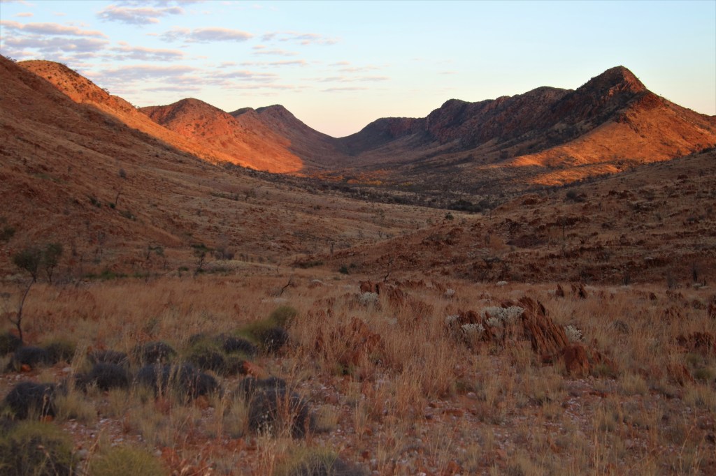
On the far side of the pass, the landscape opened up into a wide valley with broad views, through which the trail gently ascended. Apart from crossing a few low saddles, and traversing some rough rocky spurs, the walking was easy.
Wide Valley between Inarlanga Pass and Waterfall Gorge.
After climbing to the final saddle (seen in the centre of the above pic,) the trail then gently descends towards Waterfall Gorge where there are excellent views ahead to a distant Mt Sonder.
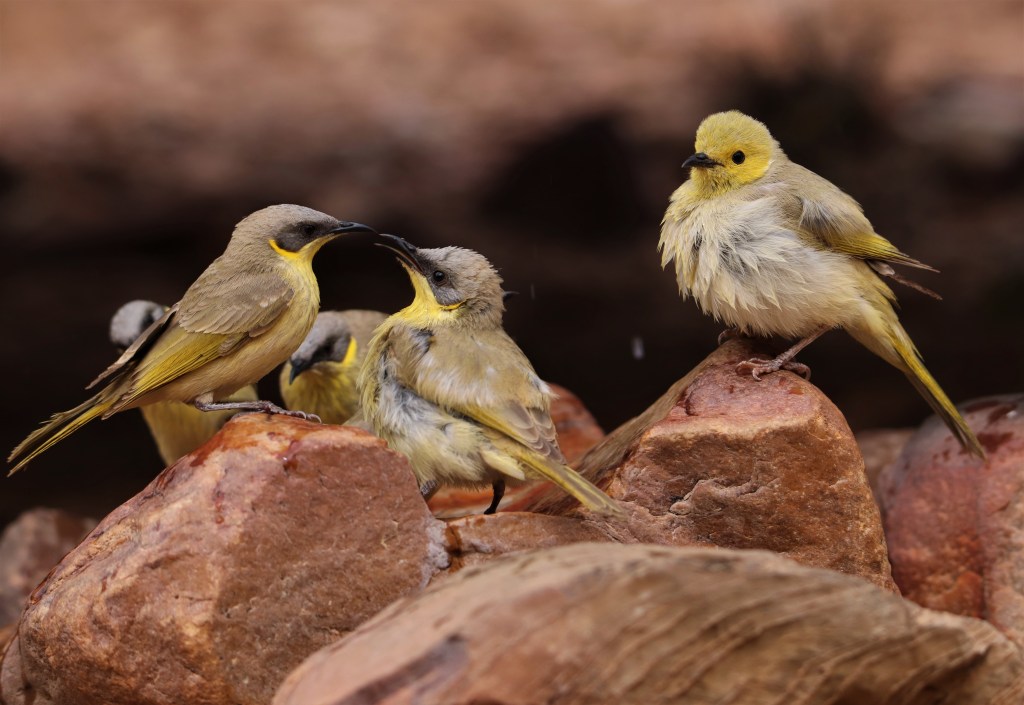
The approach into Waterfall Gorge first passed cleared tent sites, then negotiated a small steep sided pass before finally arriving at a small plunge pool. The birdlife at this small pool was unsurprisingly stupendous, this being the only water around for miles.
It was mid-morning and parts of the gorge were still in shade, so after relieving the burden of the pack I sat quietly in shade next to the pool, to watch the comings and goings. The air was thick with the sound of wing beats as throngs of Budgerigars, Grey-headed Honeyeaters, Diamond Doves and both Zebra and Painted Finches came in to drink.
Painted Finches

Water consumption was low thanks to the early start and cooler temps, and so a top-up wasn’t necessary, but in the event the water would have been fine for treating or boiling. Despite a few unappealing weed mats floating on the surface the water below was crystal clear.
Waterfall Gorge is an incredibly special place, in hindsight I would have loved to have camped the night.
The steep climb out of the gorge onto the 1088m Mt Giles Lookout was hard going despite the steps and switchbacks. It was a flashback to the hard climbs of sections four and five, although the views at the top were worth every step. I checked the weather forecast at the telstra hotspot, and the news was not good with the imminent scorching temps fast approaching.
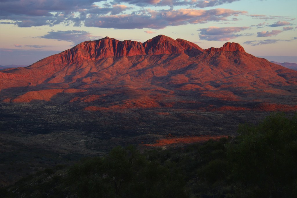
The trail then heads westwards over a bumpy and rocky ridge for four kilometres. The view ahead was one of the best on the Larapinta. In the foreground was the horseshoe-shaped Ormiston Pound, behind which, and slightly to the left was the unmistakable outline of Mount Sonder. In the distance directly behind Ormiston Pound was Mt Zeil which at 1531m is the highest in the Northern Territory.
Ormiston Pound and a distant Mount Sonder.

It was while walking along the stony ground of this ridge, eyes distracted by the captivating views, that I twisted my ankle on a rock. It was a small twist, and after some initial intense pain, I was able to carry on and descend off the ridge back to the valley floor.
The last part of the day into Ormiston Pound was onerous, trudging once again through foothills, in what had become another warm day. It didn’t help that I was exhausted after the big day of walking, too exhausted to even photograph some lovely Spinifex Pigeons encountered on the trail.
Maybe it was the anticipation of the cafe almost in reach, but the last few kilometres of the day just seemed to go on and on. A definite case of hut fever! I was at the cursing expletives stage again slogging up a sandy creek bed, on the final approach into Ormiston Gorge.
Arriving at the cafe, I saw familiar faces from the previous few days. The Adelaide three, and Anton and Matilda were busily sampling the menu, boy was I was glad to finally sit down and join them. After poring over the menu I inhaled a focaccia and toblerone, washing them down with a Mango Shake and Bundaberg Ginger Beer, no shame here!
I hobbled up to the shelter and found I was the only inhabitant that night, the other walkers camping in the abundant campgrounds surrounding Ormiston Gorge. I set up for the night, then as the temperature cooled, late afternoon I walked into Ormiston Gorge. All the stress of the day dissolved as I took in the beautiful surroundings of this picturesque gorge.
I moved carefully over the boulders searching for wildlife, only too aware that pain from the ankle twisted earlier that day had resurfaced.
Ormiston Gorge at dusk.
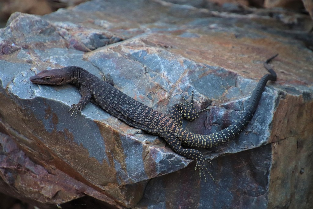
The first wildlife encountered was a beautiful Black-headed Monitor slumped over the warm rocks. It was in reptile heaven absorbing the heat. It looked very much as I felt after 9 days on the Larapinta!
Black-headed Monitor Lizard (Varanus tristis,) taking it easy!
There was an obvious boulder scree on the east side of the gorge, and I sat quietly on a rock hoping for a Rock Wallaby sighting. It was incredibly peaceful and still in the gorge as dusk descended, then from above a movement amongst the boulder scree. It was a Black-footed Rock Wallaby and then another. All the kilometres hauling my big camera lens paid off photographing these distant Wallabies.
Black-footed Rock Wallaby.
It had been a great end to a hard day, but now for some rest. I hobbled back to the shelter gathering the last of my energy to walk to the shower block and take my first shower in five days. After picking up the final LTTS food drop from the shed I returned to the shelter and crashed, safe in the knowledge that the following day was a rest day.
How Hard is the Larapinta Trail?
The Larapinta Trail is hard but achievable. I consider myself an active person, cycling 100km per week between home and work and swimming 2km most weeks, with a few gym sessions thrown in and yet I still found parts a real struggle.
I did no training for the trail, other than walking the 10km to work once a week to break in the hike boots. The first few days on the trail are going to be a big adjustment from life at home, even for those who have trained hard, but the human body quickly adjusts.
I was anxious during the first two days, this is normal. I met walkers coming the opposite direction on days eleven and twelve that were anxious, but all walkers in the middle of the trail had found their groove and settled into the routine.
Day 10 – Rest day at Ormiston Gorge – 0kms
The plan for the rest day was to walk the Ormiston Pound Walk, but as soon as I placed my foot on the ground, it was immediately obvious that I had big trouble from the ankle injury sustained the previous day. Any pressure on the ankle caused pain. This was very bad news.
Breakfast at the shelter was a morose affair as I considered the walk might be over. I had put so much heart and soul into the walk I didn’t want to have to call it off. While I sat and pondered the options an adorable Spinifex Pigeon wandered into the hut to forage for crumbs and seeds.
Strikingly patterned Spinifex Pigeons are one of my favourite birds, with their funky hairdo’s and funny mode of locomotion bobbing around like clockwork toys. I was thankful for the distraction from the current woes.
Spinifex Pigeon.

The cafe at Ormiston Gorge opens at 10am, so while I waited around for a coffee I joined Anton and Mathilda who were cooking up pancakes with fresh eggs (these guys really were gourmet!)
During this time I noticed the LTTS at the food drop, and I was glad to have the chance to chat with Emily the driver about my predicament. I advised her of my recent injury and the possibility that if I wasn’t at Redbank Gorge Carpark four days hence, not to worry, I would enact a Plan B.
Emily was a real trail angel and provided painkillers and a bandage (both of which I should have carried myself, especially being a pharmacist.) She also suggested jettisoning the gear I wouldn’t be needing into a food box to lighten the load so the company could return it to Alice Springs.
This was completely over and above what I had paid LTTS for. There had been harsh reviews online about this company not responding to e-mails. Covid had been a particularly difficult time for LTTS, having reduced their staff due to the pandemic. These people do an amazing job, they are a no-nonsense company who provide the advertised service very well. They are good people, well experienced in the outdoors. I was glad to have booked with them, and not just because of the help they provided at this time.
In the afternoon I relaxed in the gorge with Matty B who had walked in that day after a night on Mount Giles Lookout. I immersed the injured ankle in the cold water, and even enjoyed a swim.
Beautiful Ormiston Pound.
As the day progressed and I used my ankle more it very slowly improved. There was hope that I might finish the trail after all.
That evening there were a further three walkers at the hut all heading west. I moved my tent out to one of the tent sites hoping for a restful night, but this wasn’t to be with a fairly stiff breeze throughout the night.
Should I use a Trek Company to support my Larapinta Trek?
Completely upto you! I used LTTS (Larapinta Trail Trek Support.) I paid $400 for three food drops at Standley Chasm (Day 3), Ellery Creek South (Day 6,) and Ormiston Gorge (Day 9.)
LTTS then picked me up at Redbank Gorge Carpark (at the base of Mount Sonder.) and transferred me the 200 kilometres back to Alice Springs once the trail was completed. I was delighted with the excellent service LTTS provided.
On Day 9 at Ormiston Gorge, for an extra $50, I jettisoned the gear I wouldn’t be using for the final 3 days, and LTTS returned it to the accommodation in Alice Springs. This lighter load vastly improved the final three days trekking, especially the ascent of Hilltop Lookout.
As with any trail there are more and less exciting sections. There are companies that day trek the highlights, returning every night to a regular campsite owned by the company. This wasn’t how I like to walk a trail but it definitely makes sense for those with less time and more cash.
Day 11 – Ormiston Gorge to Hilltop Lookout – 18.9kms
The predicted high on this day was 35C, dangerous temperatures to be walking in indeed, and so a plan was made accordingly. The short section from Ormiston Gorge to Finke River Hut would be covered in the morning, before resting for a number of hours to escape the searing midday temps at Finke River Hut, subsequently pushing on to Hilltop Lookout mid-afternoon once the worst of the heat was over.
If the ankle injury deterioted further during the morning walk, the Plan B was to walk the short 3 kilometre spur from Finke River Hut to Namidjara Drive, and hitch a ride back to Alice Springs.
It wasn’t necessary to set out early that morning because Finke River Hut was only about a two hour walk, and so I returned to Ormiston Gorge and was rewarded with another Black-footed Rock Wallaby sighting.
A leisurely coffee would have been perfect except the cafe didn’t open till 10am. So by 8am I was back on the trail. It was a mere 8.9kms from Ormiston Gorge to Finke River Hut making this the shortest section on the track.
The walking was easy but not particularly interesting, there were occasional views ahead to Mount Sonder as the trail wound between small hills. Hilltop Lookout (not THE Hilltop Lookout,) had the best views of the morning. The ankle held up.
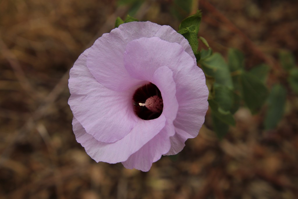
A common flower encountered along the Larapinta Trail, especially in the sand and gravelly soils of dry creek beds, is the Sturt’s Desert Rose. Named after the explorer Charles Sturt it is the floral emblem of the Northern Territory. It was always a joy to encounter the mauve-pink flowers fluttering around in the breeze next to the track.
Floral emblems of Australia:- https://www.allgreen.com.au/garden-advice/how-to-grow-the-floral-emblem-plants-of-australias-states-and-territories
Sturt’s Desert Rose.
By the time I arrived at Finke River Hut at 10am, it was already very hot and so I promptly unpacked my pillow and air mattress and had a snooze. When I woke I had a packet of soup and then spent the remainder of the five hours loading up on water. I needed to be as hydrated as possible before walking later that afternoon.
The next time I would have access to potable water was the following morning at Rocky Bar Gap Campsite 18 hours hence. There was also the matter of a big climb to Hilltop Lookout to consider between now and then.
The trees around Finke River Hut, in common with almost every tree in the Western MacDonnell Ranges at this time, contained nesting Budgies. I watched the parents return to feed the young at regular intervals, but I was not the only one watching….
I first noticed a small Black-headed Monitor Lizard (Varanus tristis,) as it foraged around the shelter for insects, after which it sun-baked next to the water tank. Recharged from the time in the sun, the Monitor Lizard climbed the trees containing Budgie nests and mounted an assault on the nest holes. I held my breath.
It squeezed into a couple of nest holes, after which there would be an almighty racket before a Budgie Chick would explode into flight. I suspect this hunting method had been fruitful easier in the season with younger newborns, there now being only a single chick in each nest hole. The remaining chicks were now fully-fledged however, large enough to defend themselves and ultimately fly away.
Black-headed Monitor hunting Budgie Chicks.

It was 3pm before I felt the day cooled enough to venture forth. Immediately on leaving the hut, the trail crossed the (dry) Finke River, afterwards crossing open flats and then winding through low spinifex-covered hills.
Ahead a line of tall trees in the floodplain signalled Davenport Creek. There creek contained enough water for a full immersion, which I did fully clothed. I hoped the wet clothes would keep me cool, but within an hour of walking they were completely dry such was the heat.
The track then crossed Mulga Woodland and was almost completely flat until the assault on Hilltop Lookout. While Hilltop Lookout dwarfed in comparison to other climbs on the Larapinta Trail it was extremely hard going as ripples of hot air drifted across the landscape. All I could do was keep putting one foot in front of the other knowing eventually I would reach the top.
Finally after many long breaks slumped over rocks, I reached the ridge and walked to the western end where a series of tent sites had been cleared. I set up the tent in the short time before sunset, cooked dinner and watched the sun set over the Central Deserts to the south of the ominous shadow of nearby Mount Sonder.
Even before sunset a plague of mosquitoes appeared, they were the worst of anywhere on the track and I quickly capitulated and retreated to the safety of the tent, over which rodents scampered during the night.
Insect Repellant on the Larapinta Trail
I packed a bottle of insect repellent for the trail, but for the first six days there were no sign of mosquitoes. This could be accounted for by a combination of cold temps, windy conditions and a lack of water around campsites, which led to a false sense of security. This all changed at Ellery Creek South when I had a first encounter with these voracious insects. Finally the insect repellent paid off.
If I thought the mosquitoes at Ellery Creek South were bad, they were like puppy dogs compared to the savage horde at Hilltop Lookout. The vampires of Transylvania had nothing on these bad boys. As soon as the sun had set, retreat to the tent was the only option. It was worth carrying the mosquito repellent.
Day 12 – Hilltop Lookout to Redbank Gorge – 15.8kms
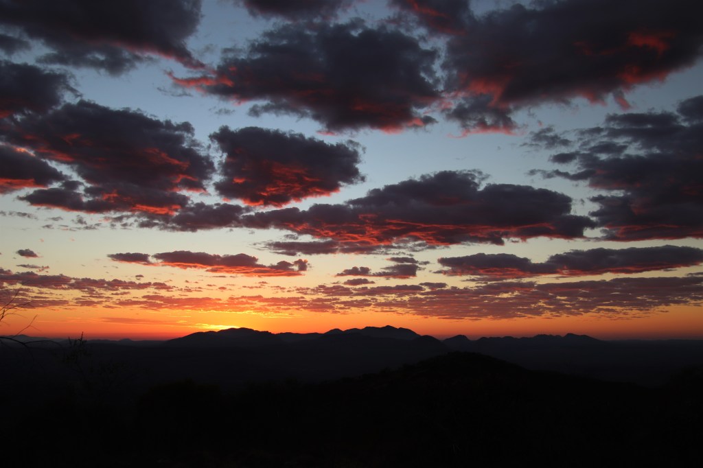
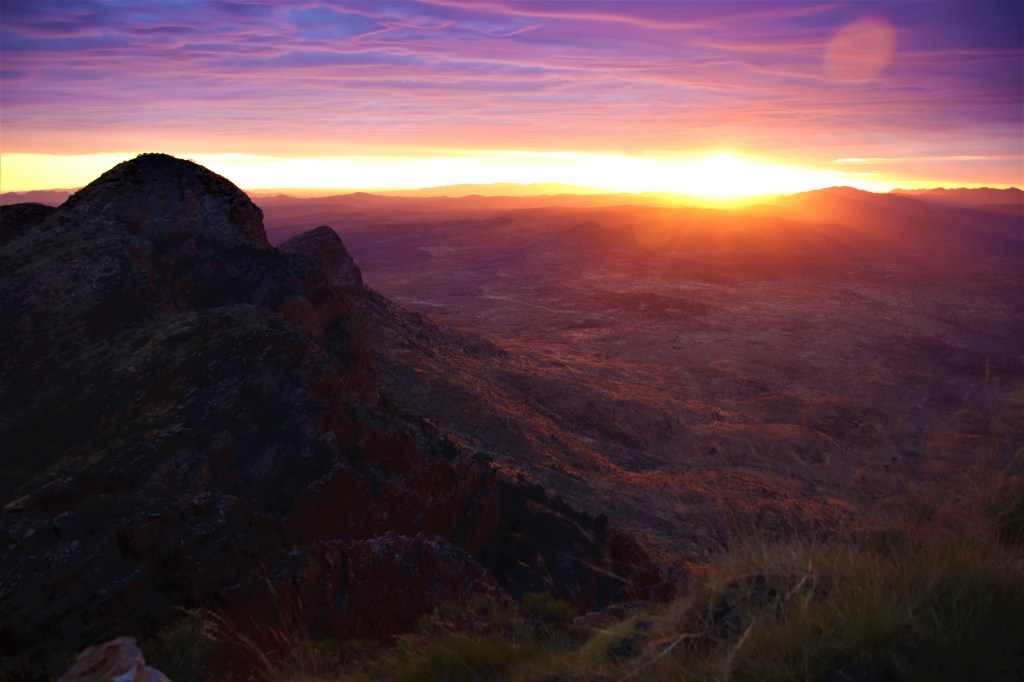
I woke at first light, delightfully alone in the middle of the desert. I could see in the pre-dawn light that there were rare overcast conditions as a result of the heat. This I hoped would add to the majesty of the imminent sunrise.
Sunrise on Hilltop Lookout.
In this part of the world Mount Sonder is king, and I was about to pay due homage. The view of the mountain from Hilltop Lookout was incredible as the east-facing buffs glowed a deep red under the first of the suns rays. At 1380m Mount Sonder is the fourth highest in the Northern Territory, sacred to the Western Arrernte people and it was clear to see why. Time and again the Larapinta Trail astounded.
Mount Sonder (Rwetyepme) Glows Red in the First Rays of Sunlight.
Within ten minutes the most intense colours of sunrise on Mount Sonder were fading, mosquitoes were still around and were quickly joined by the flies. During the night the temperatures had dipped to mere 20C, with this day came another predicted top of 35C, I needed to get walking early.
Fortunately the descent off Hilltop Lookout was gradual, and on reaching the valley floor it was flat walking all the way to Rocky Bar Gap Campsite, some of the easiest walking on the trail.
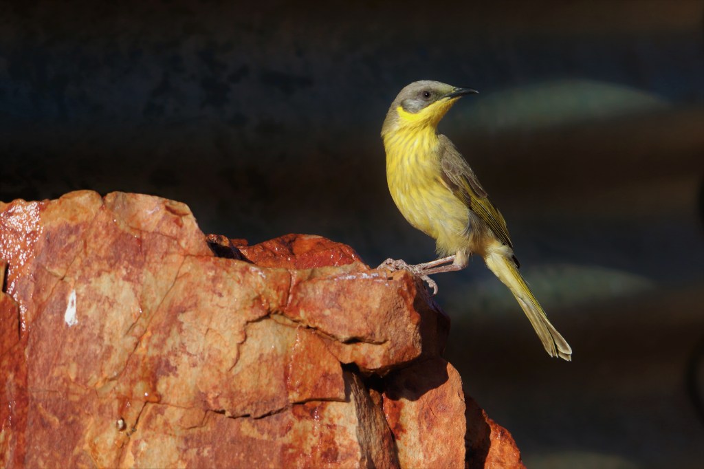
Reaching the campsite, I made a beeline for the water tank to replace dwindling supplies, which were by now under a litre. Once I had finished topping up at the tank, Grey-headed Honeyeaters flew in to bathe and drink from a pool that had formed in the rocks below.
Grey-headed Honeyeater.
I took a well-earned rest in the shade to watch the birds until it was time to head off and finish the final 11kms to Redbank Gorge. The last time I would have to carry a full pack.
The trail once again led across foothills through Mulga Woodland. As the hours ticked by the mercury climbed and climbed, so that by the time I arrived at Redbank Gorge Hut it had reached the day high of 35C. It was too hot to do much, so I languished in the hut for the remainder of the afternoon.
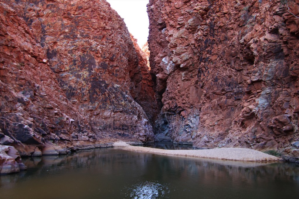
What I should have done was made the 1km walk up a dry riverbed to a pool at the mouth of Redbank Gorge, because when I finally made the short journey in the late afternoon it was much cooler than the hut. Redbank Gorge was a deep red reminiscent of the gorges of Western Australia’s Karijini NP. A dip in the icy water was sublime.
Redbank Gorge.
On dusk I returned to the shelter and ate dinner before turning in for an early night. It was still very warm and it took a while to finally drift off after much tossing and turning in the heat.
How many days to walk the Larapinta Trail?
I took a total of thirteen days to walk the Larapinta Trail, twelve days walking and one day of rest at Ormiston Gorge. This was ample time to complete the trail and yet at times it felt rushed. If I walked again, I would take fifteen or sixteen days, flexibility to stop and enjoy the many highlights.
Day 13 – Return walk from Redbank Gorge – Mount Sonder – 15.8kms
The alarm wrenched me from sleep at 3.30am, plenty of time to reach the summit of Mount Sonder for sunrise at 6.30am. Walking towards Mount Sonder for the previous six days it had become my nemesis. Today was the day I would finally face it. I couldn’t wait to get going.
The first part of the climb up a ridge on the western flank was the hardest, then the gradient became gentler as it slowly ascended along the rising crest of the ridge.
There were many climbers attempting the summit, and I could see headlamps bobbing along both ahead and behind for the duration of the climb.
Towards the summit the trail once again became steeper. Each time I lifted my head I could see the headlamps in front still ascending. I lost the trail a few times in the darkness but never for very long.
Finally, I was on the summit of the trail, but not the summit of the mountain. The eastern peak holds the title of highest point. I’m unsure if the reason the trail doesn’t go to this peak is due to the hazardous nature of the terrain, or out of respect to the Arrente people, I hope it’s the latter.
There was 30 minutes until sunrise and the group of fellow climbers milled around and chatted waiting for the moment. One of the tour guides had hilariously donned a banana costume. I gladly accepted a coffee offered by one of the Larapinta Trail Groups I had befriended at Redbank Gorge the previous afternoon.
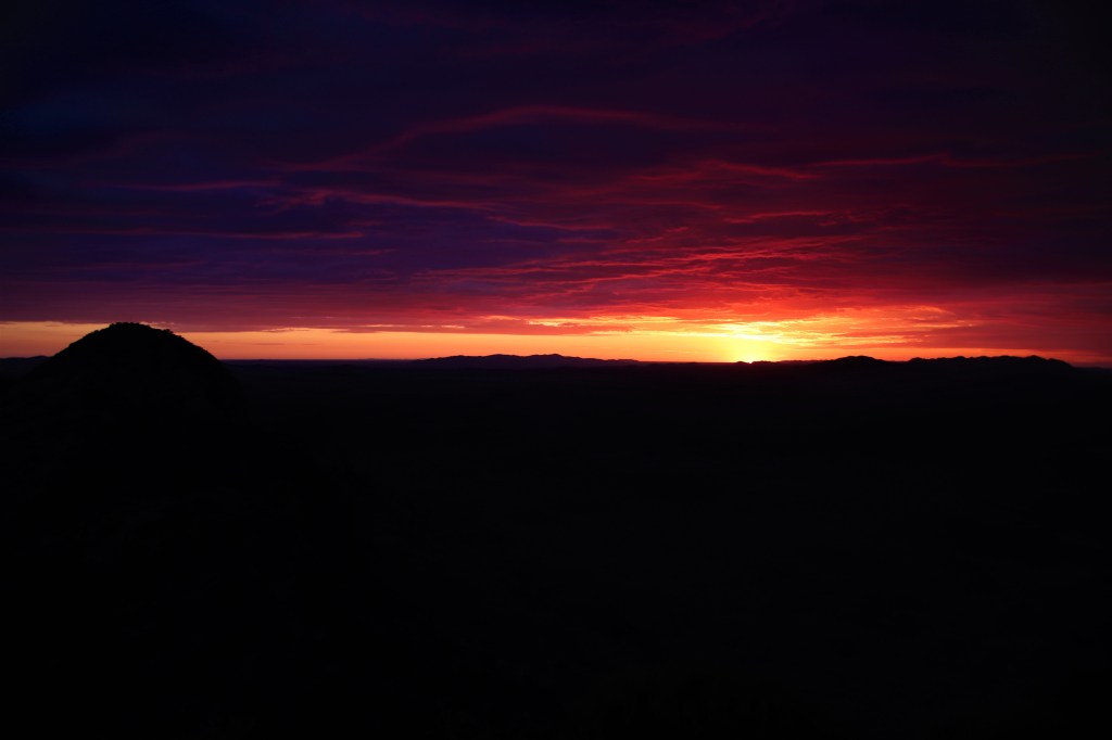
Conditions were promising for a spectacular sunrise. A cloud bank resulting from the latent heat covering the Western MacDonnell Ranges had formed, fortunately the east of the sky remained clear to accommodate the rising sun.
The moment of sunrise approached and the clouds began to glow a deep red, which increased in intensity until the sun broached the horizon. It was a truly incredible sunrise.
Sunrise from Mount Sonder, the Eastern Peak of Mountain is to the left.
As the sun rose higher it illuminated Hilltop Lookout from the previous night…
Sunrise from Sonder.
…and then it was over. Time to descend and walk the final 7.9kms of the Larapinta Trail to the Redbank Gorge Carpark.
I packed up the gear at the hut ate the last of the food, and then made the short walk to the carpark, the appointed pickup location for LTTS.
I had spare time before the 11am pick-up and used the time to watch the flocks of birds coming in to drink at the water tank. There were Budgies and all of Brown, Grey-headed, Spiny-cheeked and White-plumed Honeyeaters.
Honeyeaters at Redbank Gorge Water Tank.
Waiting for the lift back to civilisation, I thought of all the blisters, heat and sore muscles of the past thirteen days, but then I also thought of all the superlative views, wonderful people and incredible wildlife, finally I thought about the cold beer, tender steak and soft bed ahead in Alice Springs. I had finished the Larapinta Trail.
A final treat was in store during the return trip to Alice Springs when a Dingo stood in the road with a dead Varanid in it’s mouth affording excellent views, whether the varanid was roadkill or predated wasn’t clear.
How the trek be improved if I walked again?
The huts provide shelter from the elements and guaranteed water but to be accessible to rangers they are often not situated in the nicest locations. The nights camping out on the trail watching sunrises and sunsets from high peaks were the most memorable.
The day I walked from Brinkley Bluff to Hugh Gorge was through some of the best scenery on the trail but it was rushed. If I walked this day again I would have broken it into two days camping overnight at Fringe Lily Pool. This would have given me time to visit Birthday Waterhole on day four and Hugh Gorge on day five.
I loved the views at Counts Point so much, to have camped there would have been perfect. Waterfall Gorge was another very special place. To do this section again I would have camped at Counts Point, then walked to Waterfall Gorge in a day, and to Ormiston Gorge in another day.
#QuollingAround

Thanks for your detailed account and magical photos! So much wildlife and glorious sunsets! I don’t know if I have the courage to do it alone, but I think I’ll have to get out here even if with a tour group. Cheers
LikeLiked by 1 person